

'Tis the Season
Hurricane season is now really getting into full swing. Even though it officially starts on June 1st in the Northern Hemisphere, the intensity and frequency of storms really ramp up through August and into September. I’m sitting in the cockpit writing this as the latest in a string of tropical disturbances passes through and brings with it dark clouds, torrential rain, and some pretty gusty winds. This one looks like it may develop into a tropical storm and potentially a hurricane as it moves off to the west of us and across the Caribbean sea. Further to the east another disturbance is making its way across the Atlantic and will very likely be a tropical storm or hurricane by the time it reaches the Caribbean islands (hopefully) well north of us in a few days.
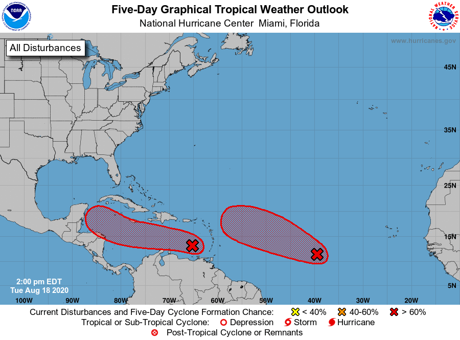
Here’s what the Atlantic storm overview looks like today. Both of these disturbances will likely become cyclones in the next couple days. Thankfully for us, the one furthest west passed right over top of us before it was able to strengthen and start spinning.
So far in our journey we’ve hung on the anchor with sustained winds in the low 40s (knots that is…otherwise known as 75kph or 46mph) and gusting to the mid-40s a few times without any trouble. Noisy and bouncy, depending on the anchorage and how much fetch the waves have to build, but our ground tackle (anchor + chain) has so far held us firm without even budging (touch wood).
Based on those experiences, I think anything more than 50kts of wind would become very nerve wracking very quickly. The noise alone might require earplugs to maintain your sanity. The most we saw in Bermuda was 47 or 48 knots but that was on the nose the whole time, in really good holding within a hurricane hole. And the situations we’ve had to-date have all been ‘regular’ storms with wind typically coming from a single direction and no circulation to worry about, which we’ve quickly learned is a major issue with cyclonic storms. Depending on whether the storm passes to the north, to the south, or right over top of you, the wind direction can back or veer through as much as 180 degrees meaning if you’re not careful your once protected anchorage can become exposed to the full force of the storm blowing you toward the beach. Yikes!
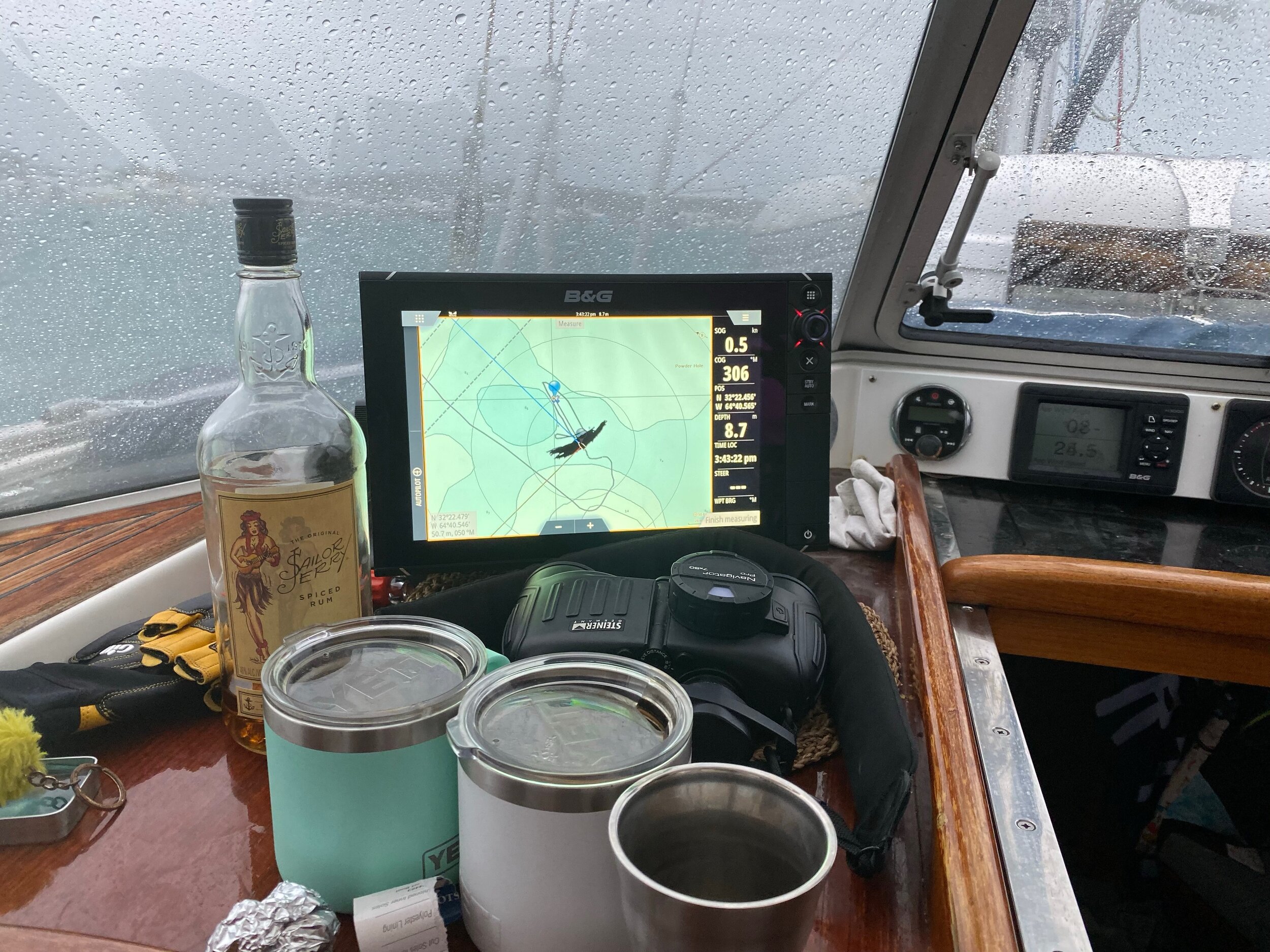
What do you do when you’re anchored in Bermuda in 45 knot winds? Oh Sailor Jerry I miss you…

When the anemometer reads into the mid-40s or higher you get an appreciation for how much noise the wind can make in your rigging.
So for now we’ve gotten into the habit of checking the forecast multiple times per day. We usually start with a quick scan of the map of Atlantic tropical disturbances from NOAA’s National Hurricane Center (updated every 3 hours). We’ve found this is the best source for the overall view of what’s going on in the Atlantic. Then we also check the analysis and forecast model ensembles from Levi Cohen’s Tropical Tidbits which give the set of different potential paths for any disturbance or storm based on the results of different weather models and scenarios. Then as a system approaches we use both Windy and PredictWind (updated every 12 hours) to give us an idea of what local conditions to expect. If there is something concerning in the forecast, we then go into planning mode which involves shortlisting potential spots in which to ride out the bad weather and getting to a consensus between Megan and I about what we would do if our first choice of anchorages is full, if the forecast changes and the storm is stronger (or weaker) than expected, if the forecast changes and the storm’s track is further north (or south) than expected, and so on. In the days leading up to a storm it becomes an all consuming amount of planning, research and discussion and has so far (fortunately) been all for naught.

Here’s the GFS forecast model ensemble for invest 98L, the eastern most disturbance in the National Hurricane Center overview pictured above.

And here’s the intensity guidance for 98L. Pretty good agreement we’re going to get a tropical storm building to potential hurricane.
Our first scare this season came with tropical storm Gonzalo which we were expecting to be tropical storm force with winds as much as 60kts when it crossed the southern windward islands somewhere between Grenada and St Vincent, pretty much exactly where we’ve been hanging out. We had just finished our first stint in the Tobago Cays and were anchored in Saltwhistle Bay on the island of Mayreau for a couple days. We’d been tracking Gonzalo’s development as it went from a tropical wave moving west from the coast of Africa then turned into a tropical disturbance, continued to get more organized into a tropical depression, then started to intensify and met the criteria for being classified as a tropical storm. Based on the forecasts at the time, we wind from the NE veering to SE and decided to relocate to Chatham Bay on Union Island to try out the anchorage for a night and see how it would work as a potential spot to ride out the storm which was expected 72 hours later to pass north of St Vincent leaving us on the weak side of the storm and far enough away to be pretty safe. While we hadn’t been there yet, we’d read the bay was mostly sand (good holding), with lots of room to spread out and get distance from other boats, and was fairly protected from every direction besides west where it was wide open.
That’s what brought us to Chatham Bay on the leeward side of Union Island on a Thursday afternoon. We knew it was a scouting mission that could turn out to be our permanent spot to ride out Gonzalo so we went into it with the intent to practice all the steps for our storm set-up. We found a spot in about 4m of water, let out 10:1 scope (that’s 60m of chain when you add the 2m from the water to the bow roller on top of the water depth) and backed down hard (2500rpm) to make sure we were well set. Liam and I also dove on the anchor to double check the set (it was dug in deep) and swam a circle around our swing radius to confirm there wasn’t anything lying on the bottom that could snarl our chain or cause some other issue if the wind clocked around and changed the direction we were hanging.
Now that the boat was firmly attached to terra firma in a spot where we felt comfortable, we turned to our checklist of preparations onboard. We brought the dinghy up on the foredeck, flipped it upside down, and used ratchet straps to make sure it wasn’t going to turn into a projectile. We deflated the stand up paddle board and stored it underneath the dinghy. We took down the bimini, which we use in decent weather because it gives standing room in the cockpit and offer open 360 degree views, and replaced it with our full cockpit enclosure which is a lot more ‘cozy’ and we know from experience can stand a lot of wind and has side and rear panels to provide all around protection. Kind of like being inside a very heavy duty tent. We stored all the other canvas items on deck (hatch covers, life raft cover, etc) and cleared off any other loose items hanging around (shoe bucket, recycling bag, fenders). It was a decent amount of work to get comfortable we were ready to see winds gusting into the 60kt range (several hours). If the storm ended up being even stronger in the next forecast we also had plans to remove ALL the items on deck (including the cockpit enclosure and cockpit cushions off), remove the solar panel and lash it flat on deck, and take the Genoa off the forestay and store below.

Here’s the PredictWind PWG (GFS based) model as of Thursday morning.
Here’s the PredictWind PWG (GFS based) model as of Thursday night. Note how much further south the forecast track has moved in just 12 hours.

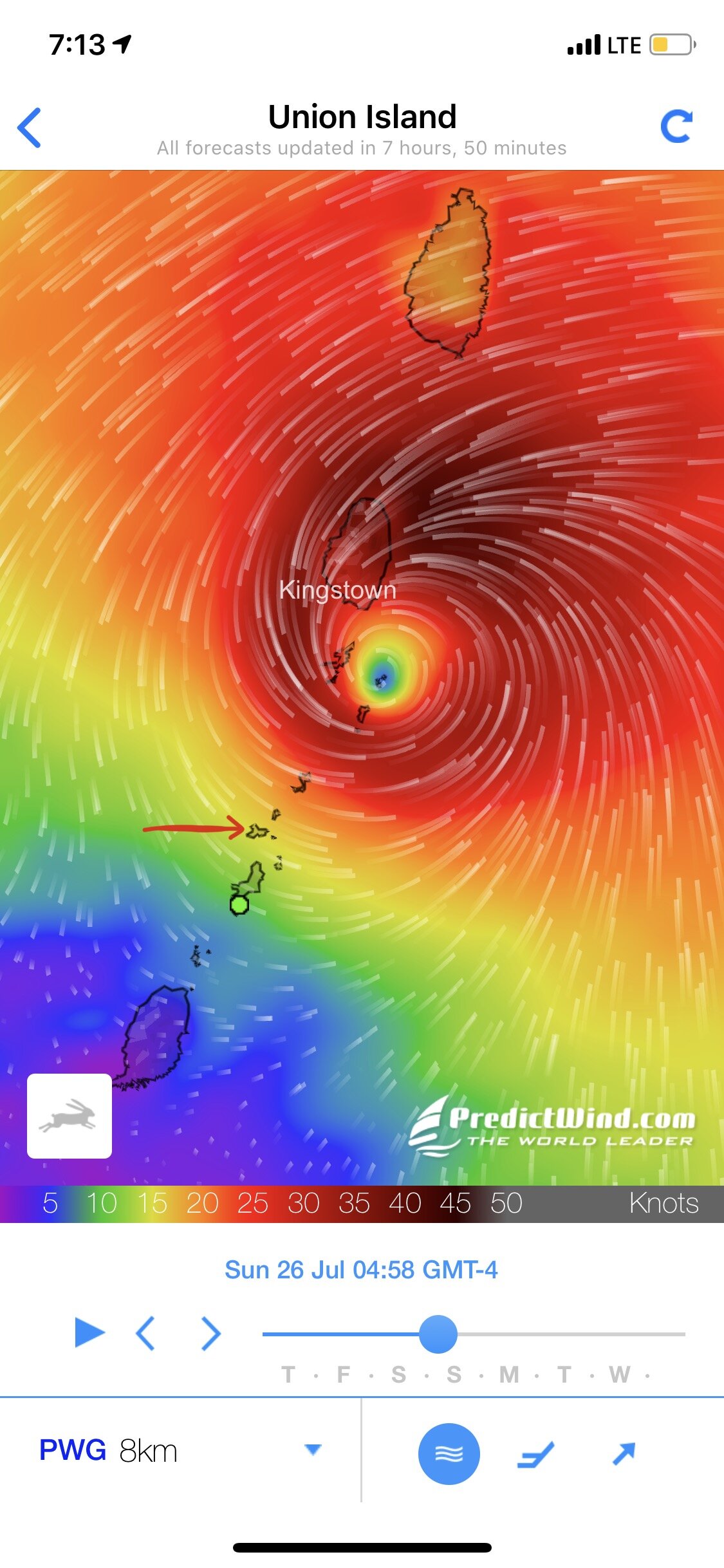
Here’s the PredictWind PWE (ECMWF based) model. Also Thursday night. Note the comparison to the PWG. The red arrow is Chatham Bay.
Phew. With spent an anxious Thursday night trying to sleep and at 5am on Friday morning woke up to check the latest forecast updates… again. Unfortunately for us we found on NOAA’s 5am update that the ECCWF and GFS models were for the first time coming into close agreement with a track projected to pass directly over Union island or possibly a few miles to the north or south. Right on top of us. Argh what an unpleasant surprise. From the beginning, the forecast for Gonzalo had a lot of uncertainty, both because the storm was fairly small making it harder to predict, as well as the lack of observation data to feed into the models because Covid had reduced commercial airline traffic to almost nothing (planes provide a lot of atmospheric observations to the weather services).
We implemented what was probably plan D or E (way down the line because we didn’t think it was likely) and made the decision to run further south and find shelter in one of the bays on the south end of Grenada. In a normal year this would be common practice; however, yacht entry into Grenada now required a two week quarantine and COVID test. We had seen confirmation from other cruisers that Grenada was allowing this safe harbour practice for Gonzalo. Again, under normal circumstances safe harbour is always granted but in COVID times there have been many occasions where Coast Guard has prevented sailors from seeking safe harbour no matter the circumstances. Since there was clearly no time for the usual entry process, we contacted the authorities and got permission to shelter in Woburn Bay under our quarantine flag as long as we didn’t go to shore. No problem since we weren’t planning to go to shore anyway! We left Union Island about 0730 for the 50 nautical mile sail down to the south end of Grenada where we arrived with lot of light left to anchor. And good thing we did because picking a spot wasn’t easy due to many boats being on mooring balls (they swing with a much smaller radius than a boat on anchor), boats on balls AND with anchors out, and even more boats not on balls with 2-4 anchors out. With so many boats with multiple anchors deployed in multiple directions, in theory limiting their swing arc or even preventing them from swinging around at all in wind shifts, the decision of where to put our (one) anchor, and our 90m of chain, was very difficult.. After a lot of debate, discussion, some indecision (always fun in a high stress moment), we found ourselves a spot with room in an area between some salty cruisers (you can just tell by the boats) and a tall ship that does 1-2 week sailing cruises but was on hiatus due to COIVD. Now with nothing to do but wait, we settled down for the night with our eye on the radar and of course those all-important forecasts. Gonzalo was expected to pass during the day on Saturday.
Again another restless night and we wake up to another dramatic forecast update showing Gonzalo now passing south of us and very close to Trinidad. Sigh. So based the best information yesterday we ran south away from the storm only to put ourselves even closer to it’s eventual path! In fact we know of multiple boats that were in Grenada originally and, following conventional wisdom, fled even FURTHER south to Trinidad in advance of Gonzalo, putting themselves directly into the zone of strongest winds.
Saturday in Woburn bay saw winds just above 30kn (not a big deal, that happens in most squalls), and no circulation or dramatic wind changes. After a better sleep Saturday night we lifted anchor Sunday morning and made the journey back to SVG at first light. We emailed a thank you to Grenada authorities and made in back to Chatham Bay in time to ride out the light westerly swell that came in following the storm. Not dangerous…just bumpy and best managed on land with a cold beer.

Here’s our track as we poked around Woburn Bay finding our spot. We would’ve liked to get further north into the bay but it was a little too shallow and a little too crowded for our comfort.

After all the lead-up, we didn’t even see enough wind to keep the kids off the deck. Especially when they’re being crazy after being cooped up on the boat for a couple days and the dinghy bottom needs scrubbing!
So all’s well that end’s well. We definitely learned a lesson to be cautious about the reliability of forecasts, especially a few days in advance, and especially this year and of a storm that size. This lesson of course makes the planning even more difficult because you need to commit to a shelter location enough in advance to give yourself time to get there, get set up, and hunker down. Depending on the radius of the storm this could be as much as 2-3 days ahead of landfall. This is obviously why many boats go to Grenada in June and just set up camp until November. Even within the country all of the above prep has to take place and boats tend to move down to the south end of the island from where ever they had been spending their time. We did not want to spend 4-5 months in Grenada, especially after spending 4 months in Dominica. SVG provides good places to ride out tropical waves, not necessarily storms and we do plan to be in Grenada for the most active months of the season (September and October).
We never thought we’d be cruising at this time of year. We thought we would have put Matriarch on the hard and been back home with family for 2 months. That plan seems so far away now. So hard to imagine the fast WiFi and Raptors games at my parents house. My waist would have expanded from the ice cream bars but my liver would have gotten a rest from the cruisers pace of drinking. However, in the COVID world of cruising we now find ourselves unable to go home, not having travelled much in the last 6 months and with an opportunity to sail within safe distance of hurricane protection. Even with this little adventure we don’t regret our decision to stay in SVG for July and August. As with every new experience we go through we learned so much and also, more importantly, gained more confidence in ourselves to manage stressful situations and remain flexible.
Pretty important skills nowadays.


